Creating Shape Scalars from a Variable
In this tutorial, we’ll use a GeoPandas dataframe with 2 columns: a geometry column of US county shapes, and a population column of numeric values. (Of course, the following steps will work for other variables besides population - any numeric input will do.
Data Prep and Cleaning
Import MapScaler and load a map of the US Counties:
import mapscaler as ms
loader = ms.MapLoader()
df = loader.fetch_counties()['df']
We’ll restrict this example to the continuous 48 for easier visualizations, so let’s drop Alaska, Hawaii, and Puerto Rico.
df = df[df.STATE_FIPS != '02'] # AK
df = df[df.STATE_FIPS != '15'] # HI
df = df[df.STATE_FIPS != '72'] # PR
Step 1: Choose a ‘base’ for scale
First, store the area of each shape as a columns in your dataframe. You can pull this in from an official GIS source (Such as the Census Bureau), or you can calculate the areas directly using the GeoPandas Shapely objects, which we’ll do here:
df['area'] = [ shape.area for shape in df['geometry'] ]
While scalars clearly define proportions, they do not specify any sizes specifically. For example, Queens County, NY has about double the population of Mecklenburg, NC. This could be satisfied by respective areas of 2 and 1, 20 and 10, 2 million and 1 million, etc. You must specify some anchor for the overall scale of the new map.
There’s no reliable programmatic way to choose this scale, because it depends highly on the distribution of shapes in your chart. Here’s the extremes:
- You could choose the densest county for your base (New York County). New York County would remain the original size, and ALL other counties would shrink. The result would be mathematically accurate proportions between counties, but they would all be very small and spaced out, an ugly visualization.
- You could choose the least dense counties for your base (Garfield County, Montana). Garfield County would remain the same size, and ALL the other counties would expand dramatically. The increased counties would all overlap each other, and mapscaler will take a very long time to find a solution with no overlapping states, and by that point, the counties will have been rearranged so much that the solution may not be recognizeable as a map of the US.
In short, it’s a tradeoff between having large individual shapes, and having a map with an overall shape that still resembles the original. Therefore, the best rule of thumb is to pick a base shape somewhere in the 60th-80th percentile of variable density. This will result in over half your shapes shrinking and less than half of them increasing. Start there and tweak as needed.
In this tutorial, we’ll use Washtenaw County, Michigan. This was determined with a small amount of trail & error by running Shape Scaler, and inspecting the output, which is covered in the next section. Store the variable value (population) and the area of your base:
base_fips = '26161'
base_population = df[df.FIPS==base_fips]['EST_POP_2019'].values[0]
base_area = df[df.FIPS==base_fips]['area'].values[0]
Step 2: Create Scalars
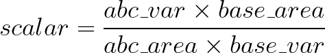
Given base values for area and a variable var, this formula will calculate the appropriate scalar by which to adjust the area of given shape abc:
Formula Explanation
The goal is to scale the area of shape abc until it has the same variable-to-area ratio as the base, like so:
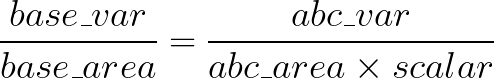
Solving for scalar gives:
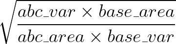
Finally, when you scale a shape’s coordinates by some scalar \(x\), the area scales at \(x2\) (see Additional Reading below). Therefore, to scale the area of a shape, the area scalar is the square root of each coordinate scalar.
df['scaleby'] = ( (df['EST_POP_2019']*base_area) / (df['area']*base_population) )**.5
This scaleby column is ready to be passed as input to Shape Scaler or Bubble Scaler, which will be covered next.